by  XIANG
XIANG
In the past few years, high-precision positioning was just needed in the driving test and other industries, but not in ordinary car navigation. Ordinary car navigation positioning accuracy is 10 meters (the positioning error may reach more than 30 meters in complex urban environment), the current common GNSS positioning accuracy can improve users after combining odometer, map road binding, vehicle filtering model and other algorithms. Experience, able to meet the navigation needs of ordinary car users.
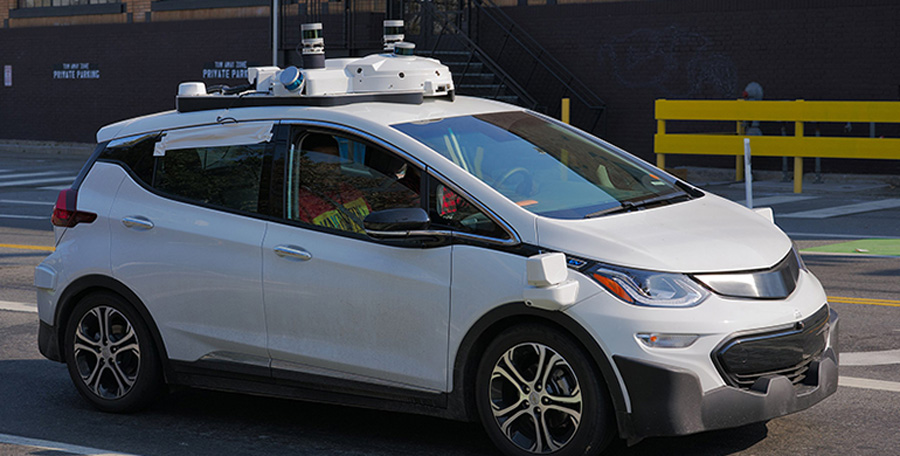
However, with the deep integration and development of information technology such as artificial intelligence, Internet of Things and big data, intelligent networked cars and automatic driving have become the development direction of the future car, and will have a revolutionary impact on road traffic. In the road environment of autonomous driving, the processing of information such as lanes, distances, roadblocks and relative positions between vehicles is the basis of autonomous driving technology, due to the automatic driving technology (especially L4/L5 level unmanned driving) for road information. A high degree of dependency requires more accurate location information.
Autopilot is not far from us. At present, the development of unmanned driving cannot be carried out in the short term, because the current security risks and policy risks will be relatively large, but it will be vertical like community/visual vehicles, goods delivery vehicles, garbage trucks, cleaning vehicles, trucks, etc. The subdivision of the field has reached the eve of the outbreak, and these industries will gradually replace the traditional vehicles with unmanned vehicles, which has become an irreversible trend. In July 2018, Baidu Apollo announced that the world's first L4-class autonomous bus "Apolon" was mass-produced with 100 units offline; and opened interfaces for low-speed park scenarios, including low-speed park perception, planning, and maps.
At the Wuxi 2018 World Internet of Things Expo, the world's first city-level road-to-road collaboration platform – the LTE-V2X city-level demonstration application project of the car network was unveiled, with 226 intersections, 5 elevated and 100,000 vehicles. Networking, let the "simple car" drive on the "smart road" and build a new ecology of "car joints". The omnipotent large-screen car, highly intelligent interactive path planning, invisible electronic signage... Each segment is a huge industry blue ocean, and high-precision positioning is possible.
1. Intelligent monitoring, scheduling and management of people, vehicles and roads, assisted driving and automatic driving through the Internet of Vehicles. So build an "Internet + Location" service open platform, build a wide-area ground-based augmentation system (differential signals provided by the broadcast system), and combine high-precision basic geographic data information (map) to achieve sub-meter or centimeter-level positioning of vehicles. High-precision positioning monitoring, track playback, alarm notification, etc. for government official vehicles, business vehicles, special operating vehicles, vehicle assisted driving, automatic vehicle driving, etc., to achieve refined management, providing reliable, stable and customized high-precision positioning The solution provides a highly accurate location service. This will be the development trend.
2. Based on the application of the "Internet + Location" service open platform, the roadside "positioning + Internet of Things" (including: traffic signs, traffic lights, intersection camera monitoring and other traffic facilities), vehicles "high-precision positioning vehicle front-mounted communication mode" The requirements of the group (ie: high-precision positioning component + network communication) products, to serve the car network, the road, the road, the city and the people (Note: can achieve the goal tracking of pedestrians through video recognition technology).
For unmanned vehicles, high-precision GNSS positioning is a must for acquiring the precise position of the user. The Baidu Apollo driverless platform uses Novatel's high-precision positioning receiver ProPak6. The 2018 Cadillac CT6 uses Trimble® RTX (Global Precision Positioning Service) technology as a high-precision GNSS/GPS differential data source to provide an accuracy of 3.8 for automated driving systems. Location information of cm.
According to the above analysis, the high-precision positioning of GNSS in the future is not limited to the driving test, surveying and mapping industries, but also become the key sensor data source for intelligent networked cars and automatic driving. In order to achieve high-precision satellite positioning, it is necessary to support the "high-precision enhancement system". In the future, every high-precision positioning user must connect to the national differential network. Therefore, the national differential network will serve as the entrance for high-precision positioning users and become a battleground for the Internet era.