1. Test Objectives
This field test focuses on the product functions and positioning performance of the X8-M1 in outdoor environments. Through simple comparative tests, the aim is to clarify the differences between the device's positioning effect and that of mobile phones, conduct in - depth research and discussion on whether the device can effectively solve the navigation and positioning pain points faced by outdoor enthusiasts, and thus enhance the user experience and safety during outdoor activities.
2. Test Arrangements
2.1 Comparative Test Devices
X8-M1 : It has 4G+ full - system full - frequency GNSS functions and supports RTK technology.
iPhone 13 Pro: 4G+ full - system single - frequency GNSS.
2.2 Test Details
Time: From 2:30 p.m. to 5:30 p.m. on February 9, 2025
Weather: Sunny
Location: Yuelu Mountain
Route: Start from Hunan Normal University Metro Station, walk counterclockwise along the mountainside of Yuelu Mountain, and finally return to the starting point.
Duration: 2 hours and 47 minutes
Distance: Approximately 9.8 kilometers
2.3 Software and Settings
Mobile Phone Software: Two - Step Road APP
Device Differencing: Qianxun
2.4 Test Personnel
Test Operator: Xu Xiaoke
Support Staff: Chen Leiyu
2.5 Holding Postures
Mobile Phone: Hold it in a normal way, with the screen facing up and the earpiece facing forward.
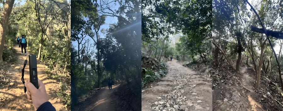
X8-M1: Hold the lower end of the device, with the antenna facing up (as shown in the left - hand figure).
3. Actual Test Environment
The test route is generally located on the mountainside, and the environment is mainly semi - occluded, with common tree - blocking phenomena.
According to the data provided by Qianxun, the ionospheric activity level at the test location that afternoon was moderate.

4. Test Data
The test data were exported from the Two - Step Road APP and the company server respectively.
Note: After the X8-M1 device test was completed, the battery level still showed full (5 bars), indicating excellent battery life.
5. Test Result Analysis
5.1 Separate Analysis of Device Data
The positioning data performance of the M10 module is as follows:
Fixed Rate: 85.9%
Float Rate: 12.8%
Single Rate: 1.4%


1. Analysis of the Number of Satellites Acquired: In the startup phase, the number of satellites acquired is more than 20. After 15 minutes, it enters the 40 range, and subsequently, it is basically stable between 40 and 50.
2. Analysis of Differential Age Data: There were several relatively obvious end - differential situations (the red part indicates more than 30s). After analyzing the on - site situation, it was basically caused by 4G signal disconnection.

5.2 Comparison with Mobile Phone Positioning Results
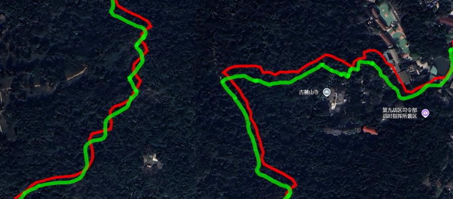
After exporting the two sets of data, they were imported into Google Earth and projected onto the satellite map. The green represents the X8-M1 device's trajectory, and the red represents the mobile phone's data trajectory.
From a macro perspective, in the mountainous area in the west, the trajectory coincidence degree of the two is relatively high; while in the urban building environment in the east, the trajectory coincidence degree is relatively low. This fully reflects that the positioning performance of mobile phones in a strong - occlusion environment such as buildings is significantly inferior to that of professional devices like X8-M1.

5.2.1 Analysis of Typical Road Sections
1. Tree - Shaded Building Streets: This section is located between Dongfanghong Square and the scenic area gate in Yuelu Mountain Scenic Area. There are many food and snack shops on both sides of the road. The environment is relatively complex, with the upper part covered by large trees and 2 to 3 - story houses on both sides. The green trajectory of the X8-M1 device is basically stable in the middle of the road and consistent with the actual trajectory; while the red positioning trajectory of the mobile phone deviates greatly, with an error exceeding 10 meters.

2. Open Road Section Corner: This area passes through a relatively open road section and a store. The green trajectory of the X8-M1 device is consistent with the actual trajectory, and the small entrance is marked with a red circle; the red positioning trajectory of the mobile phone deviates significantly. If users use mobile phone navigation, they may mistakenly think that they need to pass through the store and take the wrong route.

3. Building and Tree - Lined Road Section: This section is a mixed route of buildings and tree - lined areas. The green trajectory of the device is consistent with the actual trajectory. At the blue - marked area, the user chose the wrong route on the right due to following the mobile phone navigation and then returned to the correct route on the left. The two routes are adjacent but have a height difference. The red trajectory of the mobile phone deviates by more than 10 meters, and in some parts, the error exceeds 20 meters, and it is difficult to distinguish the road conditions at the two fork intersections.

4. Double - Sided Building Road Section: This section is located between two high - rise buildings. The green trajectory of the device is consistent with the actual trajectory. According to the position data, the first half entered the floating - point solution, but the overall actual experience accuracy is still within 2 - 3 meters; while the red trajectory of the mobile phone drifts to other buildings, which is very likely to mislead users to choose the wrong route.

Overall, whether in a building or tree - lined environment, the green trajectory of the X8-M1 device basically coincides with the actual path, while the red positioning of the mobile phone has a large error. At complex intersections, it may guide users to choose the wrong route, bringing potential safety hazards.